In the area of the Bakony-Balaton highlands, we find one of the densest volcanic fields in Europe.
In the period between 8 and 2.5 million years ago - from the late Miocene to the Pleistocene - about 50 volcanoes were active here, but not at the same time. At the 37th International Geological Congress in Busan, South Korea on August 27, the International Union of Geological Sciences (IUGS) announced the list of the second 100 IUGS geological heritage sites, including the Bakony-Balaton Highlands, the Bakony-Balaton Geopark wrote on its Facebook page .
These sites, like the first 100, receive the recognition of the prestigious international organization because they represent the greatest scientific value: they are the world's best examples of the presentation of geological phenomena and processes. They are the sites of wonderful discoveries in the history of our planet, which served the development of the science of geology. They are found worldwide and are geologically diverse. Acknowledgment and promotion of the "Second 100" by the IUGS may lead to their further appreciation, use as educational sites and, most importantly, their preservation.
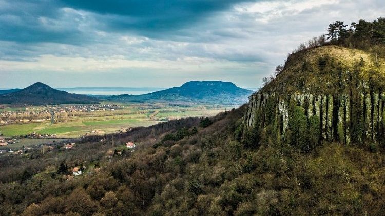
And one of these locations is now nothing more than the "inverted landscape" of the Plio-Pleistocene phreatomagmatic monogenetic volcanic field of the Bakony-Balaton highlands.
In the area of the Bakony-Balaton highlands, we find one of the densest volcanic fields in Europe: in the period between 8 and 2.5 million years ago - from the late Miocene to the Pleistocene - around 50 volcanoes were active here, but not at the same time.
The very hot, more than 1000 °C molten rock (magma) reached the surface through cracks in the earth's crust. As the magma, on its way to the surface, "met" in the depths in the medieval carbonate rocks - limestone, dolomite - and the water stored in the river and lake sediments of the former Lake Pannon - sand, clay, rock flour - that had already retreated from the area by then, usually with violent steam explosions volcanic activity began.
Mostly so-called maar-diatreme structures and tuff rings formed around their wide and deep craters. Cinder cones, lava flows and, in some cases, lava lakes have formed in many places within the craters. This volcanism was of a monogenetic nature, so the activity - although its nature changes (affects) over time even in the case of a given volcano - mostly took place "in one go".
The volcanoes of the Tapolcai basin were active between 4.5 and 3 million years ago, in the Pliocene age, and then erosion created characteristic volcanic hills, witness mountains: the level of their tops is close to the ancient surface - higher than today - on which these volcanoes were millions of years ago they broke out.
Geomorphological inversion - "reversed landscape/relief" - occurs when, during the selective destruction of the surface, over time, elevations turn into depressions or depressions turn into surface elevations. In the case of the Tapolcai basin, the latter happened: near the eruption centers, volcanic formations - more resistant to later wind and water erosion - came to the surface, while the loose sedimentary surface of the former Pannonian plain was destroyed, and today the Tapolcai basin, embellished with witness mountains, has gradually formed, an emblematic landscape.
It is important to emphasize that our witness mountains do not represent the former volcanic landforms, but their remains and ruins, often destroyed to their roots.
Reverse relief conditions are common on Earth, but landforms consisting of closely spaced phreatomagmatic volcanoes once filled with lava are rare. The IUGS recognized this special geomorphological (topographical) value with the prestigious recognition.
The emblematic Tapolcai basin has been one of the "flagships" of the Balaton Upland National Park and the Bakony-Balaton UNESCO Geopark, but this "very best of" international recognition increases the importance of this fabulous volcanic landscape even further.
Featured image: Facebook/Bakony-Balaton Geopark