Let's not dwell on the fact that otherwise the country is sociologically homogenous, there are no significant regional differences that would historically determine the political image of an area. Therefore, in connection with any transformation, referring to decades of election geography is incomprehensible both professionally and politically. Of the one hundred and seventy-six constituencies used until 2010, there are hardly any that were not won by both the left and the right in one of the five elections held after the regime change. Compared to this, it is completely secondary that in the electoral system adopted in 2011, the number of constituencies allocated to counties in eleven of the twenty counties is four or less. In these, it is almost meaningless to even talk about the possibility of manipulation.
One of the most common statements about electoral reforms is that the distribution of districts would be politically correct if the election results were the same as the previous ones. This statement assumes that the previous assignment was politically correct and conformed to the written and unwritten rules of the assignment of constituencies. However, this assumption does not hold up.
The assignment of individual parliamentary constituencies was formulated by a 1990 Council of Ministers decree. It follows from the legal source that the decree was created and adopted by the Council of Ministers, without any other control, based on the maps created by the Council Office of the Council of Ministers. The maps were compiled based on the aspects determined by the party state bodies and data requested from the county party committees and the secretaries of the executive committee of the council. The electoral map was therefore compiled on the basis of party-state interests, by the organs of the party-state, based on data that can only be controlled by them. The opposition at the time had neither the means, nor the opportunity, nor the data to overrule the drawn maps.
Let's examine with concrete examples how far the electoral district map of 1990 was free from electoral district manipulation and how far its creators complied with the requirements set out in the framework of the National Round Table!
The way and result of the division was highly manipulative. The difference in numbers and the drawing of the borders were made according to the interests of the MSZMP and the MSZP. In Budapest, in the 12th district in the Buda mountains, which is considered right-wing, there was one constituency for fifty-nine thousand voters, while in Csepel there were two constituencies for sixty-one thousand voters. It is not difficult to figure out the aspects along which the draftsmen formed these three constituencies. At the moment of its creation, there was a difference of nearly sixty percent. Whereas in the 1989 Act it was included that approximately 60,000 eligible voters should be allowed to vote in one electoral district. In Csepel, one district would have come out exactly, but instead they made two districts of 30,000 people.
The division created in 1990 was created by the party-state alone, with serious disproportionalities and the political dismemberment of connected areas. They did not even pay attention to the fact that the districts form a contiguous area. In many places, the interests of local party functionaries determined the district boundaries. An example of this can be the electoral district 1 of Pest County. This is how the ancien régime tried to save itself in the new world.
valasztas.hu
Other examples show that instead of contiguous areas, constituencies were formed based on clear political orientations.
valasztas.hu
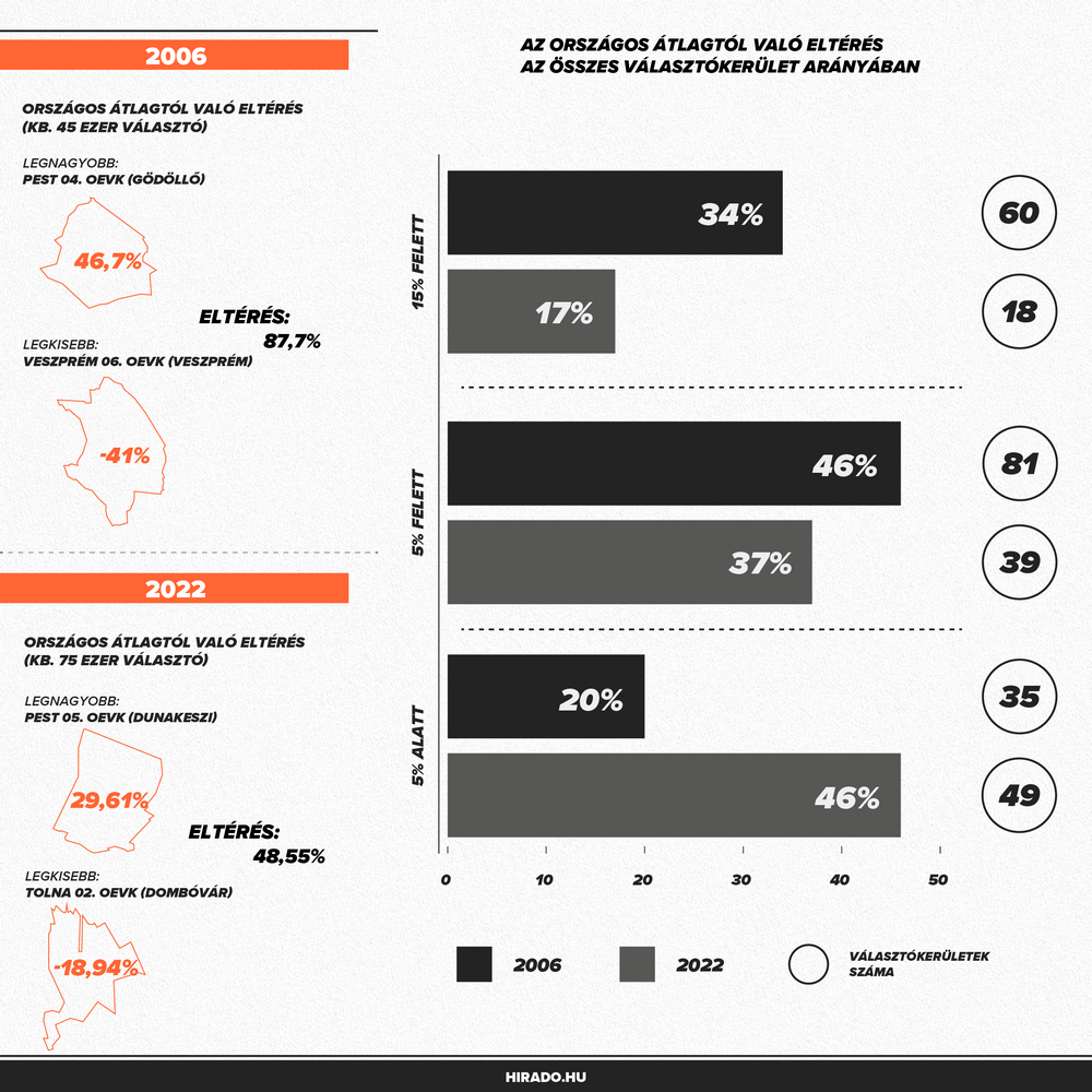
It's not that some counties didn't pay attention to the rules. In barely one-third of the one hundred and seventy-six constituencies, it was possible to keep the national differences under five percent, but in almost thirty percent, the difference was over fifteen percent at the time of adoption. In contrast, none of the new constituencies adopted in 2011 had a margin of over fifteen percent.

Over the years, of course, population movements and demographic processes always increase the disproportionality between constituencies. This is another element of the opposition's communication calling for election fraud. That the borders adopted in 2011 have become very disproportionate due to population migration in the last eleven years and this violates the principle of equal suffrage. It is therefore worth comparing how big the differences were between the population of the constituencies in 2006, when Ferenc Gyurcsány and the left won their last big victory, and how it stands now before the elections.
After what has happened so far, it will probably not surprise anyone if it turns out that the left won the election in 2006 with a seriously disproportionate distribution, which is far beyond the differences on the basis of which we will be choosing this spring.
What we are experiencing now is nothing more than the standard pace of the Hungarian left. They accuse their opponent of what they themselves have committed.
Author: Tamás Lánczi / mogasterblog.hu
(Image sources: hirado.hu, valasztas.hu)