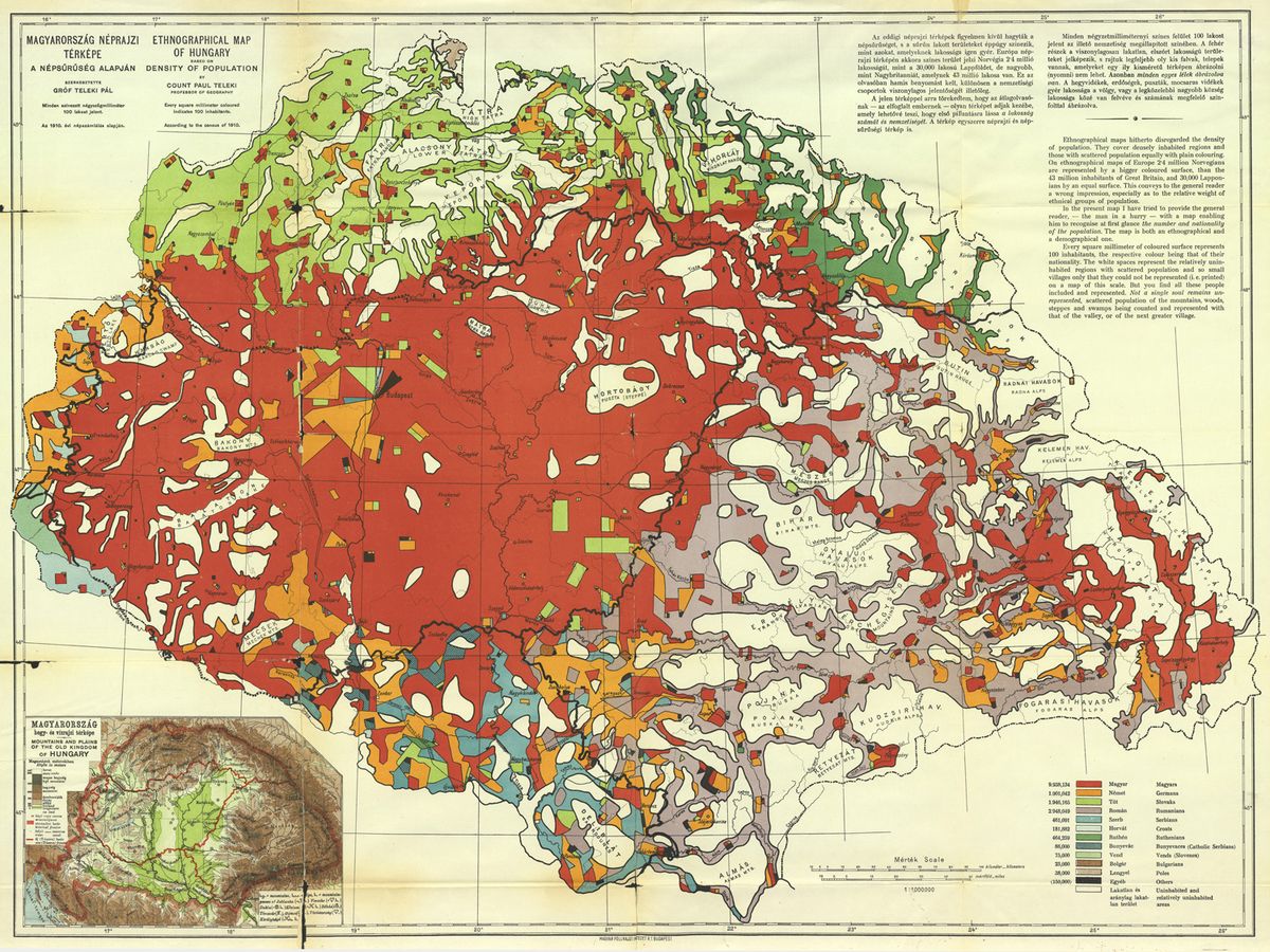
It took more than a hundred years for the scientific world to see the maps prepared for the negotiations prior to the Trianon peace decree in Paris. In his presentation, the researcher of the Institute of Hungarian Studies emphasized that the Hungarian specialists created more than sixty pieces, of which only Count Pál Teleki's map was viewed in the public part of the conference.
The researcher of the Hungarian Research Institute presented the original maps made in connection with the Trianon peace decree at a prestigious international conference. At the International Geographical Congress in Paris organized by the International Geographical Union, János Jeney, an expert at the Institute's Population Geography and Geoinformatics Research Center, highlighted to our newspaper: the first such congress was held a hundred years ago in Paris in 1922, where Hungarians could not participate.
The researcher, who gave a presentation on the re-issue of the Hungarian peace delegation maps after the First World War, highlighted in response to the Hungarian Nation's question: at the conference, he presented maps that talked about the ethnic structure of Hungary and then the number of Hungarians trapped outside the borders.
He detailed the modifications made to these maps in the years following the conference. The map series was prepared for the Hungarian delegation, among others, at the Hungarian Geographical Institute. One of these consists of 54 map sections, while most were printed on a single map sheet. The researcher emphasized that these were not allowed to be presented at the peace conference 102 years ago.
Source: Hungarian Nation
János Jeney emphasized that, in his famous speech, Albert Apponyi was the only one able to present Pál Teleki's red map in January 1920. As is well known, in the autumn of 1918 the Ministry of Foreign Affairs commissioned Count Pál Teleki, the then internationally recognized geographer, Secretary General of the Geographical Society, and later Prime Minister, to prepare the map that outlined the geographical, ethnic, economic and political conditions of the Carpathian Basin. It was based on a map on one sheet created by Zsigmond Bátky and Károly Kogutowicz, which depicted the country on 54 separate sheets at a scale of 1:200,000. The latter was completed in 1918, while the red map was completed in February 1919.
During the preparation for the peace conference, the Hungarian specialists made more than sixty maps, of which only the map made by Count Pál Teleki was viewed in the public part of the conference. János Jeney presented seven of these and their reissues in Paris.
The researcher also said that after the peace treaty entered into force, several publications appeared about the injustice of the dictation. Among them were maps that show how many Hungarians were separated by the new borders. He added: today the maps made for peace negotiations are more widely known than those published after the war.
János Jeney emphasized that the response to his presentation was surprisingly positive. The chairman of the conference emphasized that the presentation represented a very important value, as they were able to get to know a part of European history that was hardly known until now. There was also a foreign researcher who said that he did not even know that the negotiations after the World War had created such a large number of minorities in the Carpathian Basin, and he thanked the researcher for informing him about this.
At the Hungarian Research Institute, three of the above-mentioned maps have already been republished, and an interactive edition has also been completed, which can be found on the institute's website.
(It is also available directly at Trianon.térkép.mki.gov.hu.)
Source: Hungarian Nation
Featured image: Hungarian Research Institute